Our San Francisco
Our favorite city destinations
Best Views
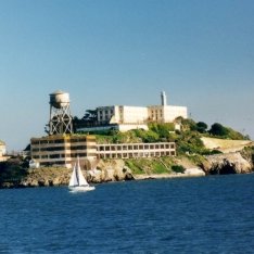
Alcatraz Island
Alcatraz Island
Alcatraz Island
The site of a former federal penitentiary may seem like an atypical location for a nice walk, but trust me, Alcatraz is worth the trip, especially since many of the structures have been renovated as part of a multi-million dollar improvement plan. The ferry ride alone offers some of the most unique, special views of San Francisco. Once you land on the island, you are welcomed by some super friendly (and humorous) park rangers then you're off to explore. Normally guided tours seem too fluffy for my taste, but the one of the cell block was well-worth the time. The tour is narrated by actual former inmates and correctional officers. Every once in a while there are special events, such as the recent art exhibit by Ai Wei-Wei, on display. Plan ahead as ferry tickets can sell out, and swimming is not an option.
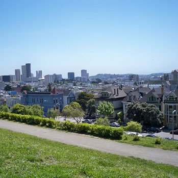
Alta Plaza Park
Jackson & Steiner
Pacific Heights
This park is gorgeous and the views are spectacular. Located on top of a hill in Pacific Heights, this park has some of the best views of the city, the bay and the Golden Gate Bridge.
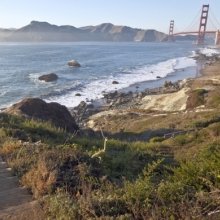
Batteries to Bluffs Trail
Batteries to Bluffs Trail - refer to map
The Presidio
Though this hike is just shy of a mile, it is perhaps one of the most strenuous. It takes you from the gun batteries along the shore to Marshall Beach that boasts some of the most amazing views of Golden Gate Park. It might be a little chilly, but braving this hike near sundown is what the locals suggest. The images during sunset are absolutely breathtaking!
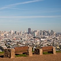
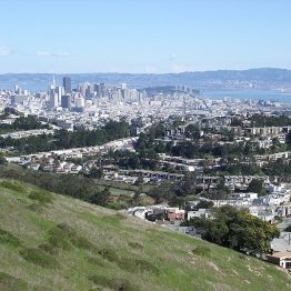
Bernal Heights Park
1501-1699 Bernal Heights Boulevard
Bernal Heights
Bernal Heights is a quaint neighborhood tucked away in the southern part of the city. The panoramic views from this park are worth the 20-minute car ride. There really isn't another place in San Francisco that allows you to see the city the way this vantage point does. The trails are excellent for a solo walk or for sharing conversations. The grassland habitat makes for a great place to spot some wildlife. The last time I was there I saw an adolescent red-tailed hawk fiercely protecting its portion of the skies. And dogs, many, many dogs. After all we are a very dog-firendly city. Take lots of pictures; make your own postcard.
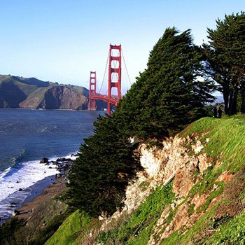
California Coastal Trail
Trailhead at the parking lot at the end of El Camino Del Mar
The California Coastal Trail runs over 1,000 miles through the Golden State. The must-see San Francisco portion begins at the northwestern corner of the city at the Sutro Baths, old ruins from the late 19th century glass-framed bath house that sat at the edge of the ocean as the Pacific washed over bathers. You continue on the trail east as it hugs the outermost northern part of the peninsula. Trees and greenery welcome you as you see the Golden Gate Bridge coyly peek through the branches.
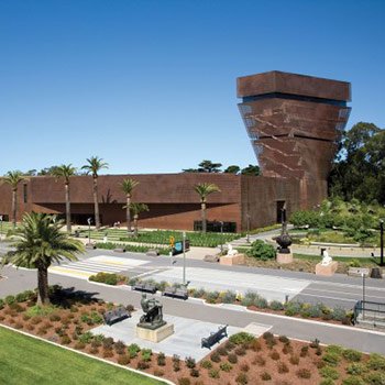
de Young Museum
50 Hagiwara Tea Garden Drive
Golden Gate Park
The de Young is one of San Francisco's premier art museums, with world-class exhibitions and a stellar permanent collection of contemporary and past era art. Its exquisite building armatured with copper siding changes hue with the environment and it is nestled in the redwood and eucalyptus groves of Golden Gate Park. There is an observatory tower that provides 360 degrees views of Marin, the Pacific Ocean, and the city of San Francisco.
Ecology Trail to the Bay Area Ridge Trail
42 Moraga Avenue
The Presidio
The Presidio of San Francisco is the largest national park that resides inside a city environment. Starting behind the historic Presidio Inn, you hike the Ecology Trail on a dirt trail through a canopy of redwoods and blackberry brambles and ascend into the Presidio Heights neighborhood. From there you switch to the Bay Area Ridge Trail, and then to the San Francisco National Cemetery where you come upon a panoramic view of the San Francisco Bay and the Golden Gate Bridge.
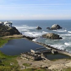
Land's End
680 Point Lobos Avenue
The Presidio
Take a car and drive out to the Sutro Baths, and visit one of San Francisco's most popular hikes in Land's End. There are quite a few options for hiking, just depends on where you want to end up and/r how long you want to hike. Regardless of which one you choose, you will have on of the best hiking experiences on your life.
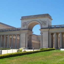
Legion of Honor
100 34th Avenue
The Presidio
Despite the location, The Legion of Honor is surprisingly easy to get to and offers free parking. Yes, free parking, which is just one of the many draws of this beautifully imagined museum. Before you even enter the grounds, walk over to the bench that overlooks the Pacific and is a grand view of the Golden Gate Bridge. Then sit at the edge of the impressive water feature. As you approach the entrance, you are met with Rodin's The Thinker. Peruse their permanent collection and definitely look into the special shows.

Marin Headlands
Marin Headlands
Sausalito
Just across Golden Gate Bridge sit the Marin Headlands which is where, I say, gun powder meets nature. This portion of the Golden Gate Recreation Area is protected by the U.S. Park Service. I don't think think there is any other hike like this one. The remnants of war are surrounded by blossoming wild flowers and foam-covered waves. There are plenty of trails to walk, run or bike and so much to see and absorb. The views of Golden Gate Bridge are spectacular so take your camera (or phone, I guess). There are ways to get there via public transport, but if possible, rent a car and make a day trip out of it.
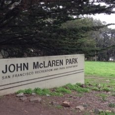
Mc Laren Park
100 John F. Shelly Way
Visitacion Valley
This park and hike sits right next to the beautiful Gleneagles golf course in a southern part of the city. The park is huge and has a number of hikes to choose from depending on where you want to start. If you need help deciding, grab a friend and try the 2.7 mile "Philosopher's Way" and perhaps some interesting conversations will arise.
Mount Davidson Park
Mount Davidson Park
West Portal
This little park is nestled between the neighborhoods of West Portal and Diamond Heights, not too far off of the actual center of the city. In a city of over 40 hills, this one sits the highest at 938 feet above sea level, which means, lucky for us, the views are off the charts amazing. It also the site of one of the world's tallest crosses which was built as a memorial to those who perished in the Armenian genocide. You can get there via public transport, though a car may be the most convenient.
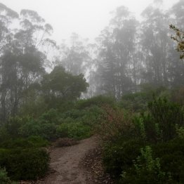
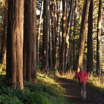
Mount Sutro Forest
Mount Sutro Forest - refer to map
Twin Peaks
You will totally forget you're in a city. When the fog is still lingering (all day at times) you will feel like you are in some sort of enchanted forest. The open space has been improved and after many painstaking, loving hours we all get to reap the benefits. Unlike some of the other summit hikes in San Francisco, this one is all about the journey. Some describe it as walking through clouds and it is just that magical.
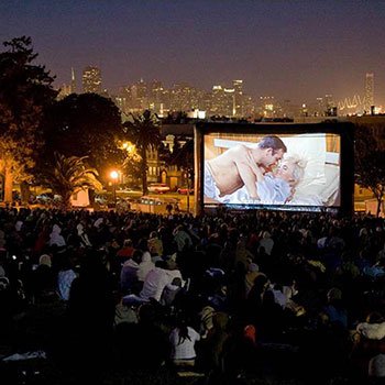
Movie Night in Dolores Park
19th & Dolores Street
Dolores Park
Movie night in Dolores Park is one of the highlights of the summer in San Francisco. The city sets up an outdoor screen and shows about six movies in total between June and September. People generally arrive before the movie begins and set up picnic blankets, bring drinks and food, and enjoy the scheduled movie outside on beautiful San Francisco nights. Always a great way to spend a lazy Saturday evening.
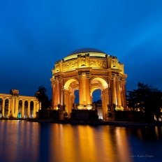
Palace of Fine Arts
3301 Lyon Street
Marina
There are few structures that have truly stood the test of time and this is definitely one of them. It was one of the ten palaces that were a part of the 1915 Panama-Pacific Exposition. During its lifetime it has been home to tennis courts, used as military storage and even a post-war telephone book distribution center. Today it is mostly a site where couples come to celebrate their union in the sight of their family and friends. It is also a great, unique place to meet some friends or colleagues for some conversation.

Samovar Tea Lounge - Yerba Buena
730 Howard Street
SOMA
In the land of coffee purveyors, this tea house chain does a mighty fine job standing on its own. Each branch holds a charm and uniqueness all its own and this one overlooking the Yerba Buena Gardens is no expectation. Come for tea and a light lunch and leave feeling lighter and brighter. Look down and enjoy the garden views or look up to appreciate the skyline. Located just south of Market Street, it's a very comfortable walk from Union Square.
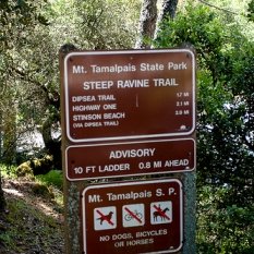
Stinson Beach to Mt. Tamalpais
Stinson Beach
Stinson Beach
This is a hike that should be on the "been-there, done-that" list for most San Franciscans. Mt. Tam, as we locals like to call it, boasts some of the most spectacular panoramic views of the bay. Most folks will spread the hike over two days camping at one of the sites near Pan Toll Ranger Station. For those who take these trails a little more seriously, you have officially been dared to complete these 17 miles in just one day. Grab a buddy or two, some supplies and brave this amazing trail.

Tank Hill Park View
2 Belgrave Avenue
Cole Valley/Parnassus Heights
"You must have a plan, a good plan and it better be a good plan," I said to my wife while sitting on the green bench situated atop Tank Hill Park. "When it comes, when the big one hits San Francisco", in the words of Nathaniel, "You stay alive.. You’re strong. You survive. You stay alive no matter what occurs. I will find you…no matter how long it takes, no matter how far. I will find you.” Quoting a line from The Last of the Mohicans seemed, at the moment, to be the right thing to say to her. We made a pact to meet on top of this very hill at this very bench when the inevitable big one that every San Franciscan knows will hit - hits. There is something about this place and you can feel it once you walk up the railroad steps to the end of the path overlooking our little city, maybe it is the semitone light or the throws of mist holding onto the trees ... maybe it is from this particular vantage point you are able to see the city in a way unlike the obvious postcards of San Francisco views because it is not the obvious. This is not the "packaged" San Francisco the world is familiar with. This view is human and as you see the city beyond the Cable Cars and Full House houses, you see neighborhoods of people living on the side of little mountains each house holding onto the side of hills with a firm grip keeping an eye on each other as to say, "I'm not going anywhere, no need to worry, I'm still here" as each house & building blends & bends... while the sun is setting, holding fast and holding on. This is the view where you fall in love, this is the view where you promise everything to the person next to you, this is the view where you plan to meet when all else fails... find me here and I will find you. If you travel to the top of Tank Hill Park Path please notice there is a casted brass dedication on the green bench to Lily from her husband David and consider for a moment the path behind you, the one in front of you and this vantage point and take a deep breath, sit down and think of those who you love. Agreements are made on this spot of the earth, words can not describe.
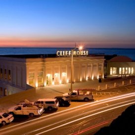
The Cliff House - Sutro's and The Bistro
1090 Point Lobos
The Sunset
You can spend the entire day in this part of San Francisco and almost forget about the "city". After visiting the Sutra Baths, plan to have dinner at either Sutro's or The Bistro. The Pacific Ocean is viewable from every seat in the house in both eateries. You will need a car to get there, isn't that what cabs are for??
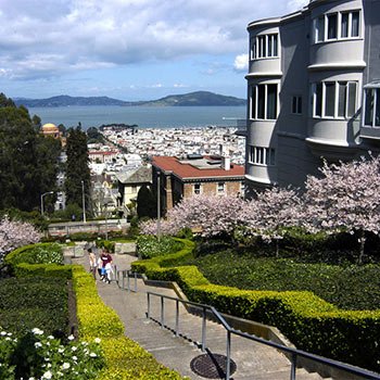
The Lyon Street Steps
Lyon Street & Green Street
Pacific Heights
Rising from the foot of the Marina to the tips of Pacific Heights, the historic Lyon Street steps provide a great workout to both the cardio junkie seeking a challenge to the tourist perambulating the neighborhoods. The views are spectacular and the real estate voyeurism is even better.
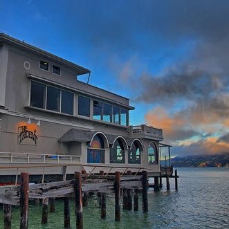
The Trident
558 Bridgeway
Sausalito
Enjoy a glass of wine and first of the season Dungeness crab on the heated bayside patio, or next to an enormous bay window in The Trident’s psychedelic dining room—either way you’ll gaze upon the twinkling lights of San Francisco with one of the best views from across the bay.
Twin Peaks Summit
Twin Peaks Summit - refer to map
Clarendon Heights
I'm not sure what the exact address is and no matter, I seem to successful find my way there regardless. Use the map or just tell the driver "Twin Peaks, please" and you'll be there in no time from Union Square. There are a couple of ways to get up to the summit. However you decide to get up there, once you do, get ready to be overwhelmed in all the best ways. Take photos, if you must, and make sure to take it ALL in. The spectacular panoramic views will have you paying homage to Twin Peaks every time you visit San Francisco. Try not to keep it to yourself and invite a friend or two along. Amazing conversations ahead!